About Us - History
Site History
Up to the late 18th Century the Merkinch was an island. The River Ness had two outlets; the one we see today and another, which left the river-course in the vicinity of what is now Wells Street. The Roy map of 1747-55 (below) shows this outflow to the Beauly Firth had been filled in.
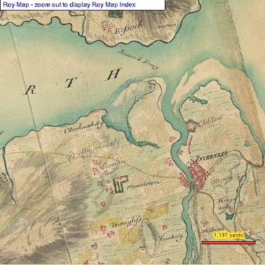
Roy Map (National Library Scotland) 1747-55
The mouth of the former outlet of the River Ness was very wide and stretched in an arc from Clachnaharry across the then smaller Carse lands to the South Kessock Pier. At this time there were unenclosed strips of cultivation but little in the way of buildings apart from the ferry cottage.
The outlet from the Ness was filled in to become, in time, Abban Street (the word Abhainn in gaelic means, a river). The much increased flow of water, which surged through the remaining outlet of the river contributed greatly to the later development of industry on the Merkinch and the Shore Street banks of the Ness. The building of the canal started in 1803 and was completed and opened in 1822. Muirtown locks were built in 1813, thus separating the site from the village of Clachnaharry.
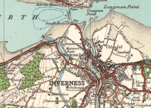
![Map of Inverness - National Library of Scotland [Edinburgh : J. Wood], 1821](https://www.merkinchlnr.org.uk/graphics/inverness_map2.jpg)
National Library of Scotland [Edinburgh : J. Wood], 1821
Additional changes were created by the construction of the seawall, thought to have been built in 1835, that runs from the canal to the old ferry slipway, enclosing the mini-estuary.
This enclosed (presumably drained) field systems. Sluices in the sea wall allowed some tidal flow allowing the salt marsh and mudflat to remain, though these were no doubt made to allow water flowing from the wetlands out to sea. The next major event was begun in December 1861, when the keystone of the original Ness Viaduct was laid. The swing-bridge over the Caledonian Canal was completed soon after, and the section between Inverness and Dingwall was opened on 11th June 1862. This finally cut off the area to the south east of the line from the sea and creates the freshwater lagoon to the north of the railway embankment. A burn still flows parallel with the canal at the bottom of the southern embankment.
The map below shows the area just before the construction of the main housing area of Merkinch. In the ten years between 1930 and 1940, four hundred and ninety dwellings were constructed on the South Kessock site. The accommodation provided was a mix of houses, and two storey flats ranging in size from 2 to 5 apartments.
Ordnance Survey 1929
History of past site management
- 1978 - Merkinch Community Council - created viewing point on the banks by the shore overlooking the Beauly Firth. Two benches installed. Improvement of standard of housing was felt to be of greater importance at this time so no more done. Houses were renovated a few years later.
- 1982 - Ferry between South and North Kessock withdrawn
- 1991 - Fly-tipping cleared up by local residents. NCH Action for Children Girls' Group entered Grizzly Challenge run by Youth Club Scotland - they won equal first prize. (Pop. Of Merkinch 4304) Mott MacDonald - landscape improvement opportunities plan drawn up for area between railway line and turning area and sea wall and back of Carnac Crescent.
- 1992 - Area put forward as a Beechgrove Garden project. Area was tidied, made more accessible, first phase of tree and shrub planting (eg. Eucalyptus at entrance). South Kessock Project born at this time.
- 1993 - South Kessock Dolphin-watch group formed at Merkinch.
- 1994 - Merkinch Community Council approached Highland Council for the lease of the Old Ferry Ticket Office. Opened to public on 28th August. Environmental Award from Inverness District Council for contribution to National Spring Clean Week. Small scale survey of visitors to turning area.
- 1995 - South Kessock Community Project. 3.5ha planted with native trees.
Further phases
- Extending the boardwalk to provide circular walks.
- Extending the tidal pond.
- Improving riverside views.
- Improving coastal path for disabled access.
- SK Project won 1st place in OCS/Keep Scotland Beautiful "Clean Up Scotland Challenge".
- Funding obtained for LIFE project proposal "Exhibition and feasibility plan at South Kessock ticket office".
- Beauly Firth Study group "The Future of the Beauly Firth - A public consultation and review".
- Compartments and site survey by SWT.
- 1996 - Management Plan prepared by W Vickers for SWT.
- 1999 - Included in School's Out! Site Guide for educational visits.
- 2007 - Bid for developing replacement for Old Ticket Office fails.
- 2007 - January - Merkinch Greenspace approach Highland Council re LNR November - Council endorse designation of LNR.
The Reserve
Merkinch Local Nature Reserve was designated on the 28th November 2007 after the signing of a formal agreement between the Highland Council and British Waterways on 14th November 2007. It is the only Local Nature Reserve in the Highland Council area and is the 50th Nature Reserve in Scotland.
Merkinch Local Nature Reserve consists of 54.7 hectares of land and foreshore to the west of where the River Ness enters the sea. To the south it is bounded by the Caledonian Canal, where it enters the Beauly Firth; the north western boundary of the Carse Industrial Estate and to the east by the main housing area of Merkinch. The northern boundary is down to the low water (spring) mark.
The Reserve is within walking distance of the main housing areas of Merkinch, South Kessock and the village of Clachnaharry. This comprises a total population of 12,331 (2001 census), and is within 5kms of the majority of the population of the City of Inverness (67,700 in 2004).
The Reserve is predominantly in the ownership of the Highland Council and is managed by the steering group of Merkinch Greenspace. There are no members of staff currently dedicated to the management of the Reserve.